The Application of Resistivity Tomography Method in Cave Exploration
Abstract: The resistivity tomography method is based on ordinary to collect the high-density data and then to form a high-density and rich-content resistively section. It can reflext the basic characteristics of geologic body objectively and exactly through the analysis and processing of the geoelectric data. This paper makes a brief overview on the resistivity tomography of principle, method and mechanism of the formation of cave. The detection and discovery of the cave at Xihuling Scenic Area Lushi county, China, has great significance and value for the developement of this place. Using resistively tomography method can make the explanation work more convenient and intuitive, and has good relevance, effectiveness and feasibility.
Keywords: resistivity tomograpy method, geophysical explorations, cave exploration
Introduction:
The general VES method is hard to study the ground section construction and deployment by the less points. On the basis of general electrical sounding method, the electrical imaging method was developed, which is easy to detect the underground materials. The array includes wenner, schlumberger, pole-pole, pole-dipole, dipole-dipole and so on.
The project of cave exploration at Xihuling Scenic Area of Lushi county takes 2D Resistivity imaging method with a good working efficiency and direct result.
The array is mainly wenner α for apparent resistivity. The instrument is WGMD-4 Resistivity/IP imaging system.
There include 10 profiles in total; among these 3 long profiles with length of 600m, 300m, 300m; the lest 7 profiles longs 2150m totally.
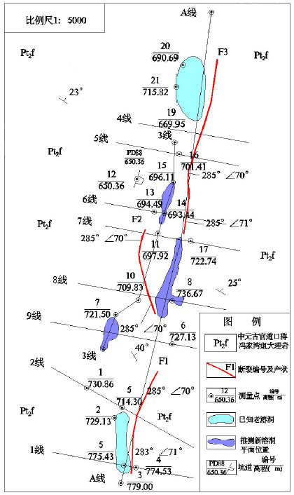
Fig.1 Comprehensive plan of the geological and measurement in the West Huling cave
Investigation result:
Fig 2. Survey line A with land reform
Fig 3. Survey line A without land reform
Fig 3. Survey line 1 with land reform

Fig 4. Survey line 3 with land reform
Form above result, 3 caves with abnormal were be found:
-
Survey line 3, pile no. 41~49
-
Survey line A, pile no. 20~27
-
Survey line 3, pile no. 1~8
Conclusion:
The results shows that the shape of the cave is obvious, the extent of plane delineation is basically the same as the tunnel, and the depth is more intuitive by the resistivity imaging method. The pricision up to 2.2~5m, which means the resistivity imaging tomography method is good at cave exploration, which features easy operation, high working efficiency and low cost.


 ENGLISH
 Chinese
 Russian

