The application of the method for interpretation of magnetic △T anomalies in the low magnetic latitude area to gold ore prognosis in Tanzania
Abstract: Situated in a low magnetic latitude area, Tanzania lies in a horizontally magnetized environment. The characteristics of △T anomalies caused by magnetic bodies in this area differ greatly from those in the middle magnetic latitude area of mainland China. Based on the application and study of the measured data, this paper put forward the interpretation train of thought and a “phase reversal 180°” interpretation method for △T anomalies in the low magnetic latitude area and applied approaches to the interpretation of magnetic △T anomalies in a mid-high latitude. The application and study of the measured data show that the effect of the interpretation is consistent fairly well with practical geological situation.
Equipment:
WCZ-1 proton magnetometer
Tanzania located at eastern Africa, 1°-11.5°south latitude as a low magnetic area, is full of mineral source. And 90﹪ is Archean greenstone belt goldmine, which is closely related with the Archean Nyanzian zone.
The gold mine should located on the northern-west area features seasonal swamps, flat and few becrock. According to the magnetic characteristics of rocks and minerals, WCZ-1 proton magnetometer with a higher precision take a good role on the exploration.
Working and analysis:
According to the north-south trend on this area, to layout the survey line on east-west direction, survey net 250m x 250m. Take WCZ-1 to carry out total field measurement. Then take Diurnal variation correction through WCZ-1, normal field correction and height correction by MAGS2.0 software.
After diurnal variation correction, normal field correction and height correction, because of the low latitude, △T mainly features negative anomaly(negative anomaly> positive anomaly), which resulted by that the △T anomaly of magnetic body consists of horizontal component Ha on the environment mainly with horizontal magnetization. If ignore the remanence impact, it could transfer the △T anomaly on low latitude with 180°phase inversion as a high latitude one. That will be easy to analysis as a middle-high latitude anomaly.
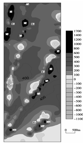
Fig 1. Contour map of △T after 180°phase inversion
From above figure,there is four magnetic anomalies, named anomaly as C, C1,C2,C3; anomaly zone as M, M1,M2,M3.
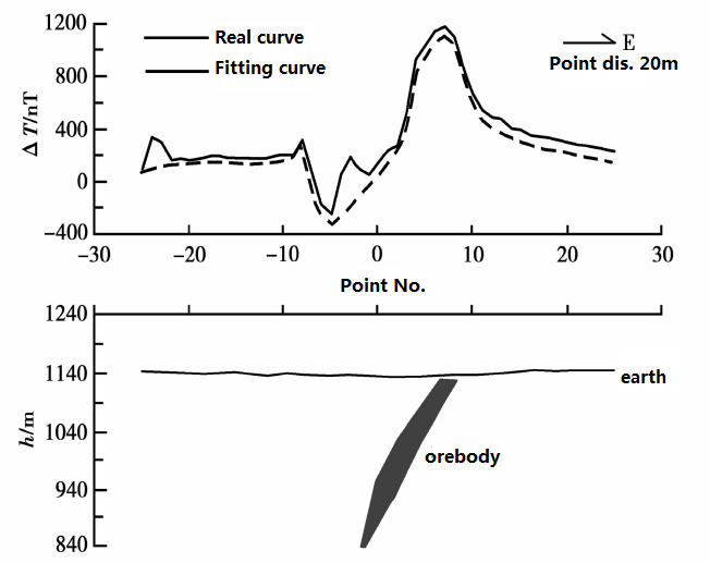
M1 anomaly zone located on the northern west of working field, composed of C1 and C4, on south - north direction long 2500m and wide 200m on east – west direction. There is odd iron cements and iron formation rocks. The gradient variation of both positive anomalies is high, max up to 2134nT. According to the shape and scale of magnetic anomaly, combined with the geological features, to pole and upward continuant the result, we inferred that M1 magnetic abnormality is lead by mineralization. So to make a test on C1 along east-west line, after 180°phase inversion on real data and data procession, we finally deduce that the orebody is on west-down direction in a shallow depth.
Fig.2 Inversion profile
M2 anomaly zone locates in the middle west of work-zone, tally has two positive anomalies and two negative anomalies as(C2,C3,C5,C10),which locate north-south forward. On north-south longs around 6000m long and wide 250m on east-west direction. There is odd iron cements and iron formation rocks. △T has three positive ones and two negative ones, the lowest is -1200 nT, the highest is 1800 nT; According to the shape and scale of magnetic anomaly, combined with the geological features, to pole and upward continuant the result, we inferred that M2 magnetic abnormality is lead by mineralization.
M3 anomaly zone locates in the middle east of work-zone, tally has five positive-negative anomalies as(C6,C7,C8,C9,C11), which locate north-east forward. On north-east longs around 6500m long and wide 300m on east-west direction. There is odd iron cements and iron formation rocks. △T has four positive ones and six negative ones, the lowest is -400 nT, the highest is 1040 nT; According to the shape and scale of magnetic anomaly, combined with the geological features, to pole and upward continuant the result, we inferred that M3 magnetic abnormality is lead by mineralization.
M4 anomaly zone locates in the south of work-zone, tally has two positive-negative anomalies as(C12,C13), which locate north-east forward. On north-east longs around 6500m long and wide 300m on east-west direction. There is odd iron cements and iron formation rocks. △T has a positive ones and two negative ones, the lowest is -600 nT, the highest is 80 nT; According to the shape and scale of magnetic anomaly, combined with the geological features, to pole and upward continuant the result, we inferred that M4 magnetic abnormality is lead by mineralization.
After drilling, finally prove the result is the same with real condition.
Conclusion:
a. this area has a strong magnetism
b. the high precision magnetic method works effectively, be economic and operated easily.
c. The ground is flat, the data analysis almost not be effected by the terrain.
d. Take △T anomaly and 180°phase inversion, then transfer to mid-high latitude data will be easy for later data analysis.
 ENGLISH
 Chinese
 Russian

