Application of the Multi-Electrode Resistivity Imaging to Detecting Water-eroded Caves in UAE
Abstract:
Khalifa City B of United Arab Emirates (UAE) is a newly planned city, which is situated in the desert seashore of the Persian Gulf. There are a lot of water-eroded caves developed underground because a lot of Subkha evaporite minerals such as gypsum exist in the Tertiary and Quatemary strata. The water-eroded caves are buried deep in 5~15m beneath the ground. These caves are adverse factors to city construction and industrial zone development. We applied multi-electrode resistivity imaging on this survey, overcame high resistivity of the surface and hard discrimination between the water-eroded caves and its wall rocks, prospected deep into 20m and finally gain the information of water-eroded cave distribution. The survey results were evaluated by UAE experts through borehole survey and excavation. The conclusion shows that resistivity survey is reliable and has achieved satisfactory result.
Key words: multi-electrode resistivity imaging, desert, water-eroded caves, UAE
Fujian Institute of Engineering Geophysics Exploration, has been competing with some professional geophysical prospecting companies from UK, Canada, etc, and successively succeeds three times in bids due to advanced technology and satisfactory measured results.
Herein this article the survey instance is performed in Khalifa City B, in a desert. Electrode array configuration applied is 2-pole electrode array, and method is multi-electrode resistivity imaging, which help to obtain information of water-eroded caves that are deep into 20m. Through two-year work (1999.8~2001.6), we have accomplished resistivity survey of 42km 2 in this region, of more than 500km-long survey lines. These surveys detect more than 2000 water-eroded caves in the desert region, on which we encircle two karst-cave-developing belts, one is 5km long and 2~3km wide, and another is 3km long and 150m wide. This discovery is valuable reference for city layout planning. Moreover, we have borehole surveyed more than 550 sites (including check of non-karst-cave anomaly), almost 80% of which are proved to be accurate.
The measured results are highly valued by the other party. In a word, it reaches the preliminary purpose.
1. Overview of the Survey Region
United Arab Emirates is located in the East section of Arabian Peninsula. Except for a few low hills stand in the East and Northeast of the nation, altitude of most parts are desert plain that is no more than 200m, belonging to tropical desert climate. North of Abu Dhabi is Persian Gulf, with flat landform whose relative height difference is within 5m.
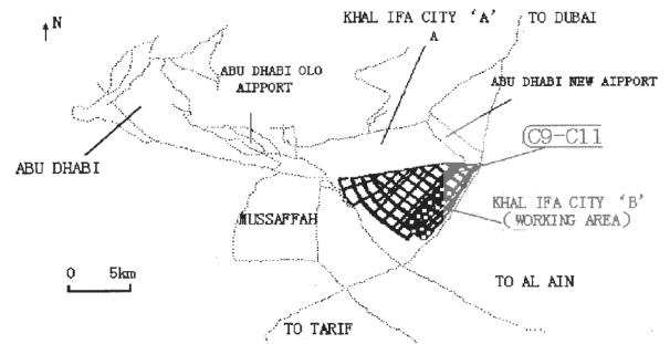
Fig. 1 Diagram showing the location of the surveyed area in Khalifa City B
The survey region is Southeast to the capital Abu Dhabi, 20km away. North of the survey region is adjacent to the Kalifa City A and Abu Dhabi New Airport. C9, C10 and C11 survey station are situated in the Northeast corner of the survey region.
2. Regional Geology and Characteristics
2.1 Geologic Features
With seashore geologic environment, the fundamental strata of this region are the same with those of the Arabian Gulf region. Lithology is mainly carbonate rocks, such as limestone, siltstone, bioclastic limestone and calcareous siltstone, on top is siltstone, mudstone, gypsum, loose sand and salty yellow soil. Gypsumobvious can forms a different layer, but some gypsummix with mudstone, calcareous siltstone and siltstone in alayer. Mixture of gypsum, salts, mudstone and siltstone forms the hard surface crust. Water-eroded caves (also including the water leakage section found during borehole survey, the same below) mainly develop on the boundaries of the upper strata, as well as develop in gypsum layer or argillaceous gypsumlayer. Few caves are discovered in layer of mudstone, gritstone and siltstone. Water-eroded cave development is in close relationship with gypsum slayer and strata boundary.
80% of water-eroded caves are not large, with depth no more than 0.6m. Only two of them are relatively higher in vertical span, one is 2.7m, another is 3.1m. Majority of them are separate, some bead-strung water-eroded caves and multilayer water-eroded caves are also found there. Level extension of some caves reach several meters, while some are only 10cm~20cm. Bead-strung of kart cave is up to tens of meters long, the multilayer water-eroded caves are general have 2~3 layers. The already proved multi-layer water-eroded cave is buried 8 meters deep, which is composed of 5 layers of caves, about 1.9m high. Water-eroded caves mostly develop at 5m~12m deep. The shallowest cave roof is in 3m and the deepest water-eroded cave roof is in 20m.
2.2 Electric Property
Limited by the environmental conditions of the survey region, physical property of the rocks are unable to be inspected. However, through comparing the resistivity data of the regularly stable electric field and the borehole survey information, we eventually figure out the relative apparent resistivity relations between each layer: mudstone< gritstone< argillaceous gypsum layer (including gypsum mudstone, gypsum siltstone, mixture of gypsum and mudstone, clayey gypsum, etc.) <gypsum. However, as level of high salinity underground water is different from distribution of the rock layers, different from this relationship, resistivity of each layer may alter at some section, except for the gypsum stratum whose resistivity appears relatively stable and high. Generally, resistivity of this region is low, while the surface is artificially filled soil and sand whose resistivity are about several to tens of ohm, or higher up to hundreds of ohm to thousands of ohm.
Electric property of the water-eroded caves in this region is complicated. Since that the water-eroded caves are located below the underground water, there are often inrush of high salinity groundwater as well as clayey sand, and there are fissures of fault developing around the water-eroded caves, therefore, a tremendous inductive medium is formed around the water-eroded caves, and the observed caves are not only low in electrical resistivity but larger in scale as well, much larger than the actual cave, ranging from ten meters to tens of meters. That is why electrical method can find deep and smaller caves in this region. It can find caves with 20cm~30cm vertical span or even 10cm, but 10~20m deep. The resistivity anomaly of the water-eroded caves on the profile is reflection of the low resistivity anomaly, and apparent resistivity varies great, from several Ohm/m to 20Ohm/m.
Different sections are different in resistivity, that is to say, speaking to its surrounding media, water-eroded caves are lower in resistivity. No matter what anomalies they have, majority of the water-eroded caves have a low-resistivity center, apparent resistivity increasing layer by layer from the center to its outside. There is few variation of apparent resistivity at the center of the anomaly, while the outer layers are larger in variation and the electrical gradient is steep. In conclusion, there are mainly three types of apparent resistivity of the water-eroded cave, namely, regular low-resistivity anomaly, layer boundary anomaly and the low-resistivity anomaly point of the thick layer.
Advantageous factor of this survey region is that it is adjacent to the gulf, flat in landform and resistivity value will not be tortured by the hypsography, and thus enables the electrical survey to go smoothly. However, some adverse factors bring great troubles for field survey, anomaly interpretation and correct judgment, such as troubles of high salinity of the underground and
highly-mineralized seawater, tiny discrimination between electrical property of the water-eroded caves and its wall rocks, artificially filled and high-resistivity surface soil and loose sand which is extremely high in contact resistance. Therefore, during the survey process, we have to dig holes and water the soil to improve the contact conditions and the instrument on sensibility and measuring precision, as well as to develop suitable data interpretation software for this region to obtain better geologic results.
3. Geophysical Property of the Survey Sites
3.1 Geology Overview of Survey Sector
C9, C10 and C11 survey sites are located in the Northeast corner of the survey region, at the top of a mild sloping field, with area of about 3km 2 , 104m~113m above the sea level. The surface is artificially filled soil, on which outcrop of weathered or half-weathered gritstone are seen. Borehole survey proves that gritstone of these survey sites are relative thicker, mostly 5m~11m, or thick up to 16m. The layers beneath the gritstone are mudstone, gypsum, argillaceous gypsum, mixture of gypsum and mudstone, gypsum mudstone, gypsum mixed with mudstone, mudstone mixed with gypsum, etc. Water-eroded caves mainly develop on gritstone and the boundaries of the lower strata; few are also formed in other layers. Scale of the water-eroded cave of this site is smaller than those in this survey region, but deeper. Vertical span of them are about 0.2 m ~ 0.5m, maximum vertical span is up to 1.8m, deep into 8m~11m. The shallowest cave roof is deep in 7m, and the deepest cave roof is deep in 14m.
3.2 Working Method and Technology
Take into consideration of the regional geologic features, of the task that prospecting water-eroded caves are within 20m deep, and of the geophysical features, we determine to apply 2-pole electrode array, multi-electrode resistivity imaging method, with electrode spacing 2m, AM=2m, profile numbers N=25. Survey grid is 100m*200m. Current electrode B and potential electrode N are laid along the profile but infinity away, more than 400 meters away from the nearest potential electrode.
Multi-electrode imaging is a kind of Geotomography (GT in short) technology, an integration of electrical profiling and electric sounding. Multi-electrode sampling can improve sampling efficiency and enhance signal-to-noise ratio through multiple-stacking function. Multiple-stacking means a certain “data point” of a profile is measured several times by different current electrodes, by different potential electrodes. Data can be sampled in a short time and be handled by computer, mass in information, high in resolution and fast in speed. 2-pole electrode array is a method applied on electrical survey, boasting low-power consumption, strong signal, few man labor needed, portability, high efficiency and is ideal for fast general survey. This configuration consists of one current electrode and one potential electrode, both of which are located infinity away. Measurement of the current and the potential is realized by automatic recording and calculation of the instrument, point by point, layer by layer. Finally, the computer can handle these data and automatically plot the colored resistivity map.
3.3 Resistivity Anomaly
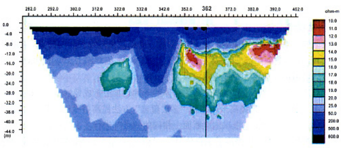
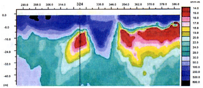
Resistivity of this sector is generally higher than that showed on the regional geological map. Resistivity of the artificially-filled-soil and sand surface is extremely high, high up to hundreds of ohm/m to one thousand ohm/m, generally, ten ohm/m to tens of ohm/m. Resistivity anomaly of water-eroded caves are reflected as lower resistivity on the profile, apparent resistivity varies a lot, 14Q·m~36Q·m. Put it another way, resistivity value of water-eroded cave in different section varies. The anomaly appears regular in axis and in steep block, ranging 20m~30m, distributed on one side of the low-resistivity section where boundary of different electrical properties are situated. For instance, on survey site C9R4 survey line, there is no hazardous geologic body exists at 270m high-resistivity section; while at 320m low-resistivity section and deep in 9.4~11m, water-eroded caves are seen between the gritstone layer and the gypsum layer (Fig.2). Another two instances, C10R6 and C10R8 survey line, which are respectively situated at 362m, 9.3~9.8m deep, and site 324m, 10m deep. The former site sees water-eroded caves in the gritstone, while the latter site sees water leakage in the gritstone layer (Fig.3, 4). Along the 105m~110m contour, a 15m~200m wide, 3km long anomaly walks along the East-West direct, on a mild sloping field.
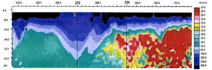
Fig. 2 Resistivity profile of survey line C9R4
Fig. 3 Resistivity profile of the survey line C10R6
The anomaly appeared on the boundary of layers of different electrical property, indicates that there is a large scale weak geologic structure which may produce water-eroded caves. The anomaly along the contour shows us that there is a buried intertidal belt which is producing water-eroded caves with the dissolvable salts, leading to formation of water-eroded caves along the contour.
Fig.4 Resistivity profile of the survey line C10R8
According to its distribution, we analyze the low-resistivity anomaly as karst-cave-developing section, and we get more than 50 boreholes there. It proves that among the 27 caves, 25 caves are located in the karst-cave-developing section. Our prospecting prediction is proved to be reliable (Fig.5).
4. Conclusion
2-year of work in Khalifa City B of United Arab Emirates, in particular the multi-electrode imaging instance at C9~C11 survey sector, sum up the following conclusion:
(1). Through multi-electrode imaging on this region, a water-eroded-developing belt discovered, more than 3km long, about 30m~70m wide. Distribution of the underground water-eroded cave is also determined and proved 80% correctness. These good survey results provide city layout planning of this region with substantial geologic information.
(2). Though this region is situated in seashore geologic environment, and the surface soil causes low-resistivity shielding because the artificially-filled-soil, desert and saline-alkaline soils, multi-electrode resistivity imaging can also be carried out to prospect small water-eroded caves within 20 meters if only something is done with the surface soil.
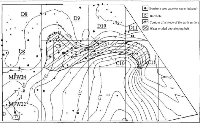
Fig.5 Diagram showing the distribution of water-eroded caves in the sector C9~C11 in Khalifa city B
(3). Because of its seashore location, the seawater inrush and high-salinity underground water, the resistivity descends in general and thus water-eroded caves has little difference with it wall rocks in electrical property.
However, CT technology can successfully acquire the distribution regularity of the water-eroded caves in this region.
 ENGLISH
 Chinese
 Russian

