Olary Iron Project Mineral Resource Estimate in South Australia
The iron ore mineralisation is ho sted by the Neoproterozoic Braemar ironstone facies of the Olary Block. The Braemar ironstone facies consists of laminated and diamictic ironstones interbedded with calcareous or dolomitic siltstone. Petrographical study shows that these rocks have metamorphosed up to amphibolite facies, but subsequently retrogressed pervasively to greenschist facies. The entire succession is further cut by centimetre-scale olivine phyric basaltic to doleritic dykes in places. With the exception of a few exposures cropped out in the North Zone,themineralisation is covered by Quaternary sediments. The geometry of the modelled mineralisation is controlled by an asymmetric east-northeast trending synform and north–east trending open folds to a lesser extent. The mineralisation is cut by a sub-vertical east–west trending fault zone that subdivides the mineralisation into the North and South Zones.
Deposit Types
The iron ore deposit at Olary is an example of Neoproterozoic ironstones that are related to glaciation and formed during the “Snowball Earth” period, when there was a global-scale glaciation even at low latitudes. The Braemar facies ironstone is envisaged to have accumulated in a marine basin along the border of a continental glaciated highland and a low-lying weathered landmass. The interlayering relationship between dolostones, manganiferous siltstones, ironstones and diamictites are related to a transgressive event during a postglacial period.
Exploration
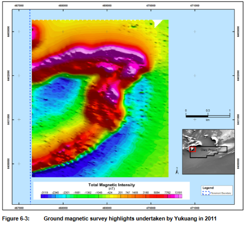
The geology of the Project area is described in the 1:25,000 scale Olary (SI 54-2) geological map and the 1:10,000 Oakvale geological map, prepared by Department of Primary Industries and Resources of South Australia. The area is also covered by the regional aeromagnetic survey, which was flowed by the Targeted Exploration Initiative, South Australia (TEiSA) in 1999-2000 at 200 m spacing. In the regional aeromagnetic data, the Braemar facies ironstones show up as pronounced, curvilinear, high magnetic anomalies. The mostly covered Braemar facies ironstones appear to have been folded and extend discontinuously for at least 180 km. In late 2010, Avocet completed 6 RC holes for a total of 689 m to test the geophysical anomalies, interpreted to represent the Braemar facies ironstones. In July 2011, a ground magnetic survey was completed over the area of interest by Yukuang. The survey was performed using a WCZ-1 Proton Magnetometer. Line and survey station spacing was 100 m and 20 m respectively. The survey was conducted between 467300E – 470400 E and 6399700N–6403200N, measuring 11.2 km2
Interpretation and Conclusions
SRK considers that the drilling methods and procedures used at the Olary Iron are consistent with generally accepted industry best practices and are therefore appropriate. In the opinion of SRK, the sampling preparation, security and analytical procedures used by Yukuang are consistent with generally accepted industry best practices and are therefore appropriate. The Olary Iron deposit Resource estimate classifications could be improved by tighter geological modelling in the areas where the banding of Iron grades demonstrates high downhole variability within the current modelled domains. To enable a coherent volume model based on tighter geological definition additional infill drilling along strike is required to confidently align the correct units with each other along strike. The aim of the infill drilling would be to enable explicit domain definition for the high grade iron population, averaging around 40% Fe, as seen in the histogram of the current fresh domains. Infill drilling and tighter domaining should enable coherent variograms to be modelled for each variable which will in turn improve the confidence in the estimate on a block by block scale as well as on the whole.
 ENGLISH
 Chinese
 Russian

