Application on Red-Sandstone Layer with Combined Electrode Profiling & IP Methods
Abstract:
Through association of Combined Electrode Profiling (3P-PRFEL) approach and induced polarization (IP) survey, a water-abundant faultage structure has been found in the survey region which is located in Xiangxiang red-sandstone layer basin, Changsha Province, PRC. This discovery has also been proved by geological borehole surveying. Quality and volume of the waters from where is also analyzed and are evidence of our expectation. This survey practice leads us to the idea that association of Combined Electrode Profiling approach and induced polarization survey works and is effective to find water in red-sandstone layer region.
Background:
Dongshan School was built in 1895. At present, there are in all 8,000 students, teacher and logistic workers, who are in severe want of water for life. However, Dongshan School is located in Xiangxiang red-sandstone basin, groundwater resource is in shortage and difficult to find. To solve this problem, Hunan Institute of Geological Engineering Exploration performed this investigation around the school region to get knowledge of the geological structure relating to groundwater and to give preliminary analysis, and thus provide reference for later borehole selection.
1. Geology & Survey Conditions:
Dongshan School is located in Xiangxiang Basin, Hunan Province. Xiangxiang Basin walks along Northeast, in strip, 8~13km in width and 52km in length. This basin is formed in Mesozoic and Cenozoic, based on Cathaysian landform. During the formation, Cathaysian kept on its historical activity and controlled Xiangxiang basin. Another typical example of its activity is the Dongtai Mountain faultage. The lower plate of the cracked faultage is filled with water, playing an important role in hydrogeology. The sedimentary basin formation in Cretaceous, Paleogene, Neogene features sediment, are mainly from composition mud stone, argillaceous sandstone, calcareous silt. Because the sediment of these sandstones looks red, it then acquires the name of
“Red-sandstone Layer”. Hydrogeology of red-sandstone layer is poor and rare in underground water; it is a typical water-in-want geologic structure.
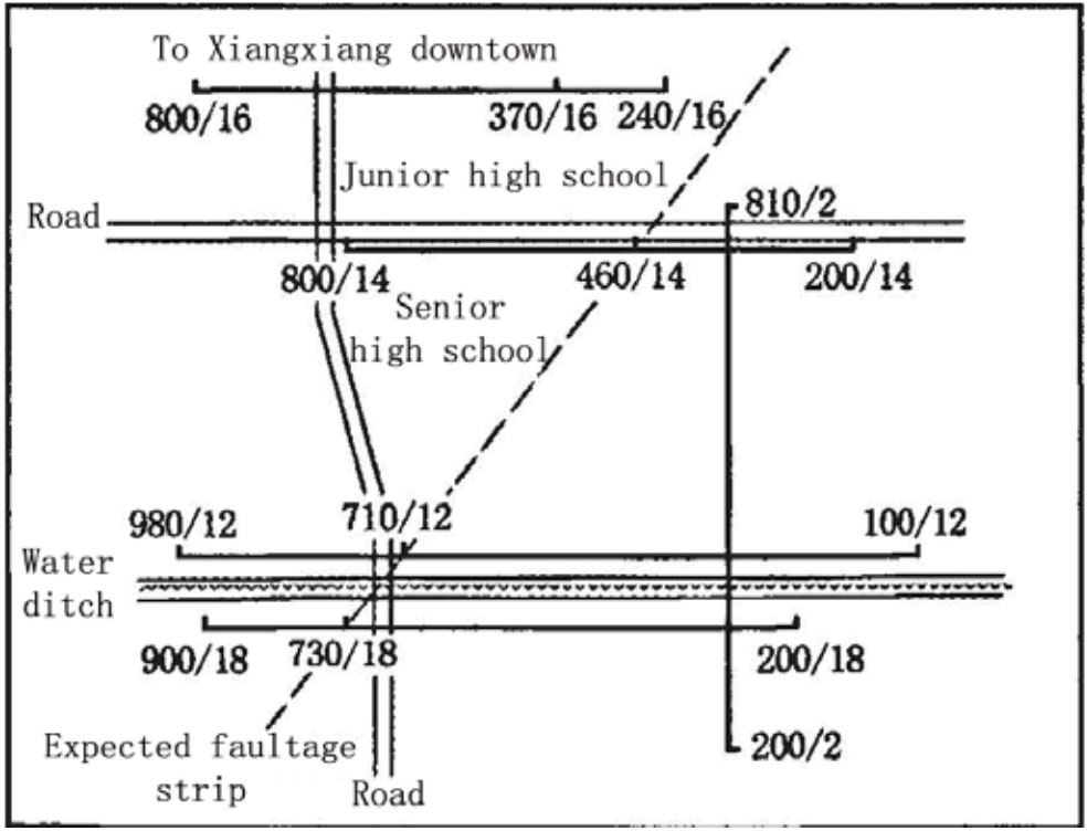
Dongshan School is just located in the middle of the Xiangxiang Basin. In front of it is Lianshui River, back is Dongtai Mountain. We chose the survey region on the Ⅱ terrace of Lianshui River which was formed in Quaternary Pleistocene. The topography is plat, no much variation in altitude, about 43~49m of Yellow Sea, higher in South and lower in North in general. Red-sandstone Layer is the main geology of this survey region. When the faultage structure is filled with water, anomaly of the data curve by Combined Electrode Profiling is positive point and apparent resistivity is about tens of Ohm · meter, while anomaly of VES curve of induced polarization is as the following analysis: apparent resistivity ( ) decreases, form a low resistivity anomaly, and polarizability ( ) appears high value anomaly.
On judgment of this point, we can expect that aquifer or water-abundant region is located somewhere.
2. Field Design & Working Method
In consideration of lack of detailed information of the regional geology, after investigation of the field and topography, we designed 4 survey lines along east-west direction and 1 survey line along south-north direction. First, we apply Combined Electrode Profiling, one array with shorter electrode distance, AB/2=65, MN/2=5, Spacing=10m, another array with longer electrode distance, AB/2=110, MN/2=10, Spacing=20m. This method as we know is VES (Vertical Electric Sounding) induced polarization survey. It will give us detailed information of vertical layers and also evaluate the volume of water. Electrode array configuration is Schlumberger array, MN/AB=1/5, AB max /2=130 m. Instrument applied on this survey is BTSK WDJD-3 multi-function Digital DC Resistivity/IP meter.
3. Data Analysis
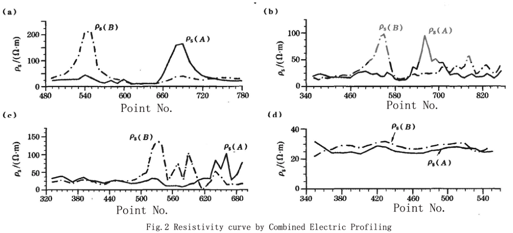
There are three positive joints appears, at Point 730/18 (Fig.2c), Point 710/12 (Fig.2b), Point 460/14 (Fig.2c), which are caused by anomaly of low-resistivity region. Besides, both shorter electrode distance and longer electrode distance of Point 370/16 also show positive joint (a single positive point), which we could not trace the anomaly because of limitation of activity
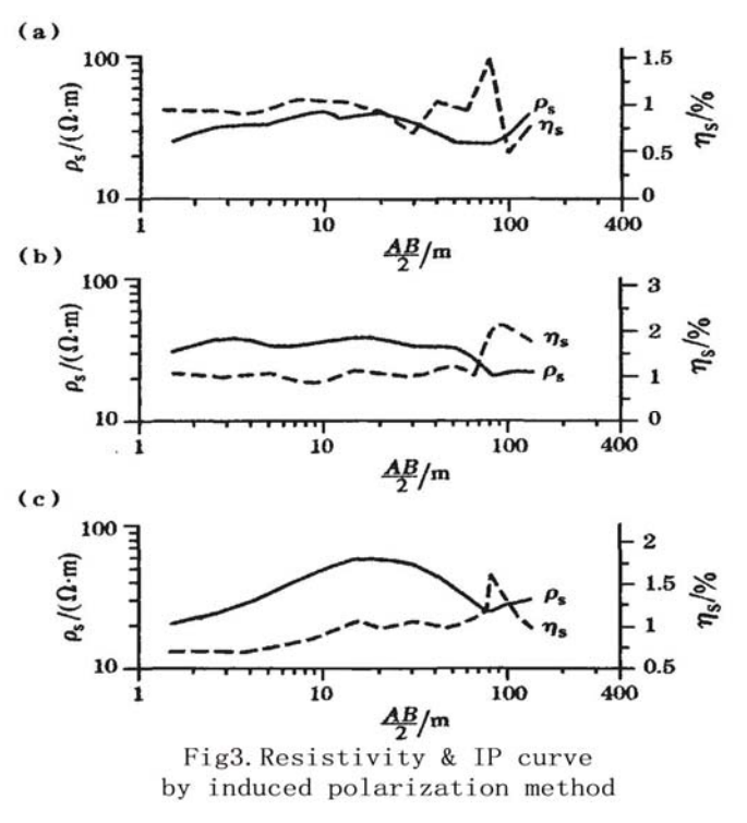
In Fig.3, there are three symmetrical VES data curves, one of them is Point 710/12 (Fig.3a) at AB/2=80, Point 460/14 (Fig.3b) at AB/2=80~90 and Point 370/16 (Fig.3c) at AB/2=80~90 111. Polarizability is relative higher, apparent resistivity is relatively lower, and both of them turn out to be anomaly of aquifer speaking to low-resistivity geology.
4. Conclusion
After field survey, data processing and analysis of the regional geology materials, we reached the result: within the survey region, there is one faultage strip, which is the aquifer of this survey region.
We suggest the school leader choose Point 710/12 as the borehole, dig deep into 80 meters. Later, geological borehole surveying proves that the water volume per day is more than 400 tons. Therefore, the problem of water shortage in Dongshan School is solved. This survey practice leads us to the idea that association of Combined Electrode Profiling approach and induced polarization survey works well and is effective to find water in red-sandstone layer region.
 ENGLISH
 Chinese
 Russian

