The integrated geophysical method for Iron-zinc polymetallic deposition in Mongania
Abstract:
A high-precision magnetic method and a dual-frequency IP method were used to study the influence of the iron-zinc polymetallic deposit in the Gobi province of Mongolia.
And it confirm many abnormal area with low magnetic, high visual frequency and low apparanet resisvitiy, which caused by a nuber of iron-zinc metal ore. The orebodies occur in the skarn belts formed by contact between granite and marble. The genetic the type of deposits is contact metasomatism Skarn type, deposit size is medium. The results show that the combine of high-precision magnetic method and dual-frequency IP method , is a effective methods to find out the abnormal and helpful for later exploration projects.
Key words: geophysical methods, high-precision magnetic method, dual-frequency IP method, iron-zinc polymetallic, Mongolia
Introduction:
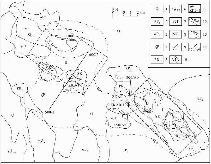
Fig 1. Geological and geophysical comprehensive planar map of the research area
1-Quaternary; 2- lower permian rhyolite and rhyolitic pyroclastic rocks; 3- lower permian andesite and tuff; 4 - lower pemian dacite and lava tuff breccia 5 - middle proterozoic shale and marbleization-limestone; 6 - middle late Jurassic granite; 7 - Triassic granosyenite 8 -skarn; 9 - geological boundary; 10 - metallogenetic prognosis area and its number; 11 - hole and its number; 12 - magnetic anomaly contour; 13 - aeromagnetic anomaly contour; 14 - survey line (IP sounding number/survey line number)
To measure the magnetic section by WCZ-3 proton magnetometer ( precison ±1nT, resolution 0.1n), the point distance is 20m ; the survey line is arranged perpendicular to the magnetic anomaly direction(NE5 ° or NE34 °); the observation parameter is the geomagnetic △ Z.
The middle gradient measurement takes WDJF-1 digitial amplitude frequency meter with the max power is 2400w(when transmitter is not constant current, the current pricesion is ±5‰ or max power is 800w( when transmitter is constant current), the current precision is ±3‰ ; the receive with current precision ±5‰,input impedance ≥50MΩ. Ite features anti-interference ability, good stability and high precision observation.
Specific working parameters: the direction of the line NE5 ° or NE34 °, power supply electrode AB = 1500m, measuring electrode MN = 40m, measuring point distance 20m, high and low frequency combination 8H8 / 13Hz, in the middle of AB 2/3 range (VH, VL), frequency of view (Fs), power supply points A, B, and measuring points were laid by Japan SET510 electronic total station (5 ") for the measurement of abnormal IP parameters.
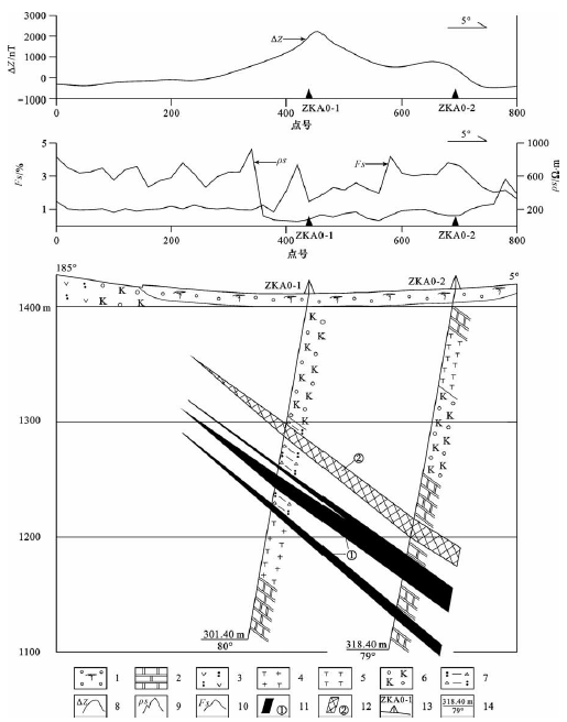
Fig.2 Geophysical anomalies and geological cross section along prospecting line A0 of the research area
1 - Quaternary; 2 - marbleization-limestone; 3- breccia tuff; 4 - granosyenite; 5 - syenite porphyry; 6 - skarn; 7 - cataclasite; 8 - magnetic anomaly ΔZ curve; 9 - apparent resistivity ρs curve; 10 - apparent amplitude frequency Fs survey; 11 - magnetite body and its number; 12 - zinc ore body and its number; 13- hole position and its number; 14 - finished hole depth/finished hole inclination
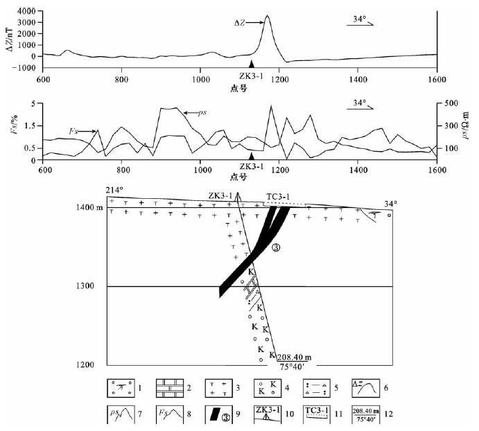
Fig 3. Geophysical anomalies and geological cross section along prospeting line 3 of the research area
1 - Quaternary; 2 - marbleization-limestone; 3- granosyenite; 4 - skarn; 5 - cataclasite; 6 - magnetic anomaly ΔZ curve; 7 - apparent resistivity ρs curve; 8 - apparent amplitude frequency Fs curve ; 9 - magnetite body and its number; 10 - hole position and its number; 11 - trench position and its number; 12 - finished hole depth/finished hole inclination
Conclusion:
(1) The metasomatic skarn-type iron-zinc polymetallic mineralization in the study area is mainly related to the Mesoproterozoic limestone, marbleized limestone and Mesozoic granite. According to the ore-forming conditions and metallogenic characteristics of the ore-forming area, it can be divided into two metallogenic prediction areas, namely, Ⅰ and Ⅱ metallogenic prediction area.
(2) In the study area, the magnetic and magnetic parameters of the rocks and minerals in the study area show that the iron-zinc ores, magnetite ores, and iron-bearing zinc skarns in the study area exhibit high magnetic, Low resistivity characteristics; zinc ore shows low magnetic, high visual frequency and low apparent resistivity characteristics.
(3) Based on the obvious differences in the characteristics of magnetic susceptibility, apparent frequency and apparent resistivity of rock (ore), a combination of high-precision magnetic measurement and dual-frequency IP method is adopted, especially by high-precision magnetic profile The combination of the measurement and the ladder profile measurement in the IP system can be used to study the low magnetic field and to delineate the low-magnetic blind orebody quickly, which is of great significance for finding the same type of ore deposits.
 ENGLISH
 Chinese
 Russian

